Mountain climbs can be rated using different methods. TourOfCalifornia.org follows the Yosemite Decimal System (YDS), a method popular in North America.
The original Yosemite Class System was created by the Sierra Club in the 1930s to classify the difficulty of hikes and climbs in the Sierra Nevada. In the 1950s a decimal extension was added to further classify the difficulty of rock climbs at Tahquitz and Suicide Rock in Southern California. The original YDS ranged from 5.0 to 5.9, but as climbers and gear got better the scale was opened. 5.10 and harder routes are subdivided into letters a through d, currently up to 5.15c. A route is rated based on its most difficult pitch, not on its overall difficulty.

Mount Whitney, East Face
Class 1: Trail hiking
Class 2: Off-trail hiking
Class 3: Scrambling (downclimb facing outward)
Class 4: Non-technical climbing (downclimb facing inward, often roped)
Class 5: Technical climbing (5.0-5.9 and 5.10a-5.15d, easy to extremely difficult)
By: B. Straehle
See Also: Climbing & Mountaineering
Summit elevation: 13,188 feet
8 miles with 3,100 feet of climbing

Route Profile
Ruby Peak • Description
Mosquito Flat, located at an elevation of 10,250 feet, marks the trailhead to Ruby Peak (Rock Creek Road, leading up to Mosquito Flat, is the highest paved road in California). The climb to the summit gets progressively more challenging, from trail hiking to off-trail hiking to scrambling to easy rock climbing.
The approach to the East Ridge follows Little Lakes Valley Trail for 0.6 miles, then it continuous on Mono Pass Trail for 1.3 miles, then it follows Ruby Lake Trail for 0.3 miles (2.2 total). At Ruby Lake the approach leaves the trail and leads along its eastern shore, before climbing to a saddle which marks the start of the East Ridge.
Most of the ascent requires scrambling and the final section requires easy rock climbing. The East Ridge gains about 2,200 feet of elevation in a little over a mile. Ruby Peak offers spectacular views of the surrounding summits and valleys with their lakes and creeks.
Ruby Peak • Interactive Map
Ruby Peak • Pictures

Approach

Approach

Ruby Peak

Approach

East Ridge

View from East Ridge

View from East Ridge

East Ridge

View from Ruby Peak

View from Ruby Peak

Ruby Peak
By: B. Straehle
See Also: Climbing & Mountaineering
Summit elevation: 10,364 feet
Approach: 3 mi round-trip with 700 ft of climbing
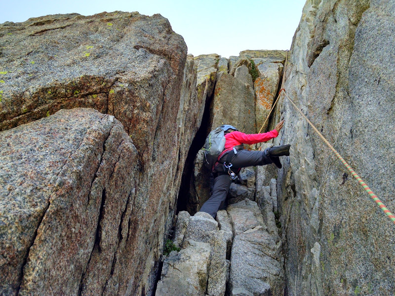
Climb: 3 pitches of 5.7 difficulty
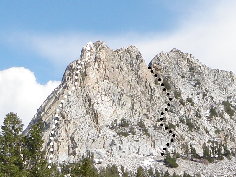
Crystal Crag, North Arête
Crystal Crag • Pitches
Crystal Crag • Description
Crystal Crag is a granite rock tower in the Mammoth Lakes area with a white quartz band at its north summit. The north and east side present some challenging rock climbs, while the south and west side offer more mellow routes.
The approach starts at Lake George (9,200 ft) and leads on Mammoth Crest Trail and Crystal Lake Trail to Crystal Lake (9,700 ft). It then continues on to the base of the climb (9,900 ft).
The North Arête consists of three pitches, the crux being a chimney at the very beginning. The descent leads down the backside of the summit via the saddle between north and south summit.
Crystal Crag • Interactive Map
Crystal Crag • Pictures

Crystal Crag

Approach
North Arête Pitch 1

North Arête Pitch 3

View of Mammoth Lakes

View of Crystal Lake

Afternoon Thunderstorm

Rappel
By: B. Straehle
See Also: Climbing & Mountaineering
Summit elevation: 8,858 feet
12 miles with 4,200 feet of climbing

Route Profile
Cucamonga Peak • Description
Icehouse Canyon, located above Mount Baldy village, is a popular trailhead.
The steep trail leads up to Icehouse Saddle, where it splits into Cucamonga Peak, Ontario Peak and Bighorn Peak, and the Three Tees. The next section leads around Bighorn Peak to a saddle between Bighorn Peak and Cucamonga Peak. The final section leads up steep switchbacks to Cucamonga Peak.
Cucamonga Peak • Interactive Map
Cucamonga Peak • Pictures

Cucamonga Peak

View of the Inland Empire

View of Mount Baldy

View of Mount San Gorgonio and Mount San Jacinto
By: B. Straehle
See Also: Hiking & Backpacking